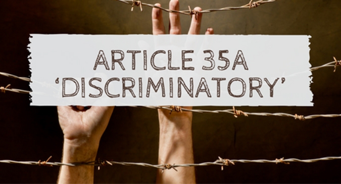
The Impact of Article 35A on the Valmiki Community in Jammu Kashmir .Part-2
| 10-Sep-2018 |
http://jkn.testbharati.com//Encyc/2018/9/10/The-Impact-of-Article-35A-on-the-Valmiki-Community-in-Jammu-Kashmir-Part-1.html
Deandra Silvalobo
History of the area.
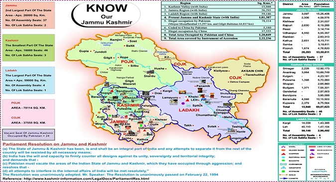
The state of Jammu and Kashmir is divided into 4 main provinces that are the areas of Jammu, Kashmir, Ladakh and Gilgit. The regions of Jammu, Kashmir, Ladakh and Gilgit shape the State of Jammu and Kashmir. The territory of Jammu and Kashmir, which had priorly been governed by Hindu rulers and Muslim sultans, turned out to be a piece of the Mughal Empire under Akbar from 1586.This area in 1819 was added to the Sikh Kingdom of Punjab having formerly been dominated by Afghan rule from 1756 till the time it was added to Punjab. This territory of Jammu was then passed over in 1820 from Maharaja Ranjit Signh, the founder and ruler of the Sikh Empire to Gulab Singh, who was the founder of the Dora dynasty as well as the first ruler of the princely state of Jammu and Kashmir. In 1846 Kashmir was additionally included and given over to Gulab Singh under the Treaty of Amritsar. Maharaja Gulab Singh annexed Ladakh in 1830.. In this way this northernmost state was established by Maharaja Gulab Singh in 1846 and was the greatest and vastest royal state in India prior to the partition of the nation in August 1947. Around then the aggregate territory of the state was 2, 22,236 sq. km. Pakistan attacked the State in October 1947. Indian powers drove Pakistan back however in 1949 when a truce line was drawn around 1/3rd of the region i.e. 78932 sq. km. which included the entire of Gilgit, Mirpur, Kotli and a piece of Poonch came into the ownership of Pakistan, abandoning just 143,30 sq. km. on the Indian side. Jammu, Udhampur, Kathua and Anantnag locale stayed unaffected. Following this in 1962 China captured around 64000 square kms in Ladakh known as Aksai Chin. Pakistan again made an illegal ownership over Chhamb, Deva, Chakla and Manawar picking up a zone of3999 sq. kms. Consequently add up to territory left on the Indian side is around 12850 sq. kms. There are numerous low lying valleys in the state like Tawi Valley, Chenab Valley, Poonch Valley, Sind Valley and Liddar Valley, however the primary Valley is the valley of Kashmir, which is 100 kms. wide and 15520.3 sq. kms. in territory. Through this valley streams the waterway Jhelum with its tributaries. The stature of the valley above ocean level is around 1700 meters. The structure of this state and territory on the map of India resembles a crown the state is 640 kms. Long from north to south and 480 kms. east to west. Chinese and Russian Turkistan are its neighbours to the north. On its east is Chinese Tibet. On the South and South-West lie the provinces of Punjab and Himachal Pradesh. On the west is the North West Frontier Provinces of Pakistan, China and Russia. Afghanistan and Pakistan now have approached the borders of the province of Jammu and Kashmir; the proximity to the borders of outside nations has made the position of the State most imperative from military perspective. The whole State lies in the vicinity of 32.17" and 36.58" North altitude and east to West, the State lies in the vicinity of 73.26" and 80.30" longitude.
Population and Demography of the state
According to the 2011 census, the total population of the state is 12,541,302. Out of which the population of Jammu is 5,378,538 and the population of Ladakh is 274,289. The population of Kashmiri valley is 6,907,622. This population includes mainly the Muslim majority. The province of Jammu and Kashmir contains different ethnic gatherings. The central ethnic faction is the Kashmiris living in the valley, the Paharis inhabiting areas around the Peer Panjal territory. The Gujjars who are the migrants and wayfarers live around the Peer panjal zone. The Dogras reside in the Udhampur and Jammu locale and the Ladakhis live in Ladakh area. The society is heterogeneous in nature, there are a few dialects talked by individuals like Kashmiri, Dogri, Pahari, Urdu, Punjabi, Ladakhi, Pashto and so forth. However Urdu written in Persian script is the official state dialect. The number of inhabitants in Jammu and Kashmir is predominantly occupied with the primary sector. The secondary and tertiary sectors are not as established as the primary one due to because of its exceptional area which precludes Corporation to set up enterprises in the hilly and uneven lands of the state.Agriculture is the principal sector of the state. It underpins roughly 80% of the populace. Since Jammu and Kashmir is notable for its picturesque magnificence, Tourism is additionally a noteworthy wellspring of salary of individuals in Kashmir valley. However in the current years because of the ascent of militancy both the segments have been influenced.
Geographical Importance and Political Conflicts
The territory of Jammu and Kashmir has obtained since the nineteenth century a special geo-political status in the Indian mainland It has touching borders with Russia, Afghanistan, Pakistan, China and Tibet that merit consistent vigil and all things considered it has made the State essential, Geologically, politically, monetarily and from the military perspective. Jammu And Kashmir State consented to the Indian Union in 1947 after the partition. Prior to that in 1947, The English leaders of India took away Gilgit in 1946 from the Maharaja of Jammu and Kashmir on rent for a long time with the goal that they could check the progression of Russia towards India.
Political relations amongst India and Pakistan tainted due to the occurrences of many reasons and in the end brought about three more wars in Kashmir:
• Indo-Pakistani War of 1965,
• the Indo-Pakistan War of 1971
• Kargill War in 1999.
About 60% of the former princely province of Jammu and Kashmir is occupied and belongs to India (Jammu, Kashmir Valley, Ladakh and Siachen Glacier);30% of the area from this state is under the Pakistan dominance (Gilgit– Baltistan and Azad Kashmir). China regulates 10% (Aksai Chin and Trans-Karakoram Tract) of the state since 1962. The Chenab blueprint was a trade-off presented in the 1960s, which stated that Kashmir valley and other Muslim-ruled territories which lie to north of the Chenab waterway would go to Pakistan, and the Hindu dominated areas such as Jammu would merge with India. The eastern district of the past regal province of Kashmir has likewise been assailed with a border question. Towards the end of the nineteenth and mid twentieth century, albeit some territory agreements were marked between Great Britain, Tibet, Afghanistan and Russia over the northern outskirts of Kashmir, China never acknowledged these assertions, and the official Chinese stance remained stagnant. With the communist insurgency in 1949, The north eastern frontier of Ladakh was invaded by the Chinese army during the mid-50s.By 1956– 57 China had finished a military street through the Aksai Chin zone to give better correspondence linking Xinjiang and western Tibet. India's overdue revelation of this street prompted boundary conflicts between the two nations that finished in the Sino-Indian war which took place in October 1962.China had captured Aksai Chin since 1962 and as well as a bordering area, the Trans-Karakoram Tract was surrendered by Pakistan to China in 1963. For irregular periods between 1957, when the state endorsed its own particular Constitution, and the passing of Sheik Abdullah in 1982, the state had rotating phases of balance and cohesion and discontent. In the late 1980s, be that as it may, stewing restlessness over the overbearing strategies of the Union Government and charges of the illicit interference in 1987 state Assembly elections set off a rough uprising which was upheld by Pakistan. From that point forward, the locale has seen a drawn out, grisly clash amongst separatists and the Indian Army, and both these groups have been accused for gross violations of human rights, atrocities such as kidnappings, slaughters, assaults and outfitted robbery. The armed force has authoritatively denied these accusations. However, viciousness in the state has been on the decrease since 2004 with the peace procedure amongst India and Pakistan
The total area under Jammu is 26,293 sq.kms and is about 25.93% of the overall area of the state the Kashmir Valley occupies about 15,948 sq.kms and is 15.73% and the territory of Ladakh stretches over 59,146 sq.kms and is covers 58.33% of the total area of the state.
The region of Jammu has an overall population of 5,350,811 people and is divided into ten districts Kathua, Jammu, Samba, Ydhampur,Reasi, Rajouri, Poonch,Doda, Ramban and Kishtwar. Jammu has 37 state assembly seats and 2 Lok Sabha seats.
The region of the Kashmir Valley also has ten districts with around 6,907,22 people residing in this region . The districts are Srinagar, Anantnag, Kulgam ,Pulwama, ,Budgam ,Ganderbal ,Bandlpora, Baramulla and Kupwara. The total numbers of State Assembly seats allotted to this area are 46 and it has 3 seats in the Lok Sabha.
Ladakh has a population of 2,90,492 people and consists of two districts they are, Kargill and Leh . Ladkh has 4 seats in the State Assembky and 1 seat in the Lok sabha.
It is to be noted that the displaced people and the inhabitants of the state who do not own a Permanent Residency Certificate are not included in the census.
The map below highlights the distribution between the regions in the state.
RESEARCH METHODOLOGY
For the purpose of conducting this study, the researcher has adopted both primary as well as secondary sources. The secondary sources were gathered through newspaper articles, research papers, and internet sources. The researcher engaged in primary data collection by conducting a field visit and preparing a detailed questionnaire with an aim of achieving a comprehensive knowledge on the study matter. The researcher designed the questionnaire by including a wide range of questions encompassing and keeping in mind the resources and time available as well as the complexity of the data to be collected. The researcher followed the semi-structured approach and was open to narratives for more in depth and detailed knowledge. The researcher adopted an obtrusive and qualitative approach where data was collected directly from the community being evaluated through survey structured with open ended questions.
HYPOTHESIS:
The hypothesis of the study is that Article 35A has a negative impact on the lives of the people belonging to the Valmiki Community in the state of Jammu and Kashmir.
SELECTION OF AREA
After migrating from Punjab under the garb of receiving the PRC of J&K , this community was made to settle in the then outskirts of the city of Jammu. However, after decades this place is now the heart of the city. The researcher conducted the survey in Gandhi Market where a large number of the community live. This study has tried to encompass the people affected living in the state by getting a comprehensive view of their lifestyle, living area etc.
METHOD OF ENQUIRY AND DATA COLLECTION
The researcher faced a language barrier while communicating with the people. This issue is a highly controversial issue in the state and thus the approach was sensitive and with empathy without overstepping boundaries. The members of the community regardless of the age group were all equally participative and voiced their respective opinions. Along with the questionnaire, the research participated in interactive discussions with the leaders as well as the youth of the community in order to achieve a wide-ranging understanding.
MODELS OF DATA SAMPLING
With a view of conducting research, random sampling of various members of the community was conducted with an objective of getting a proper representation of the community.
After collection of the data through random sampling the variables have been tabulated and analysed using simple statistical tool like percentage
| Variables | Percentage | |
| Gender | Males | 60% |
| females | 40% | |
| Age | Below 25 | 50% |
| Education | Matriculation | 50% |
| Graduates | 50% | |
| Post Graduates | 0% | |
Data Analysis
The Data analysis involved analysing both the qualitative and quantitative data collected. The following chapter deals with Analysis of the data collected on the field. It will be complemented with information collected through secondary sources as well as interview and discussion with prominent members of the community.
continue Part 3...
Tags: