The entire state Jammu and Kashmir is an integral part of India: Historical facts
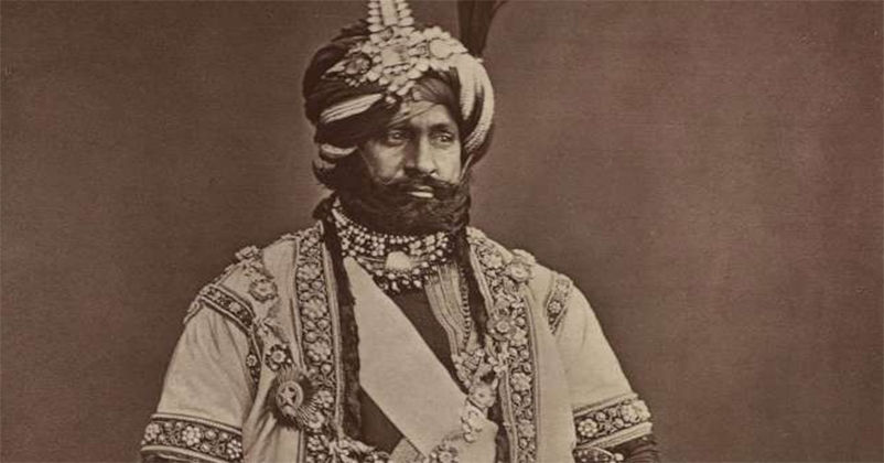
Jammu and Kashmir is the north most state of India and it was consolidated by Maharaja Gulab
Singh. The areas of Jammu, Poonch, Pir Panchal line, Chenab line, Gilgit, Muzafarabad and Kashmir Valley came together as a unit during Maharaja Gulab Singh’s regime. Most of the regions except Kashmir and Muzafarabad were under the direct administration of Maharaja Gulab Singh. Even Kashmir Valley and Muzafarabad came under his administration in 1846.
Maharaja Gulab Singh and General Zorawar Singh conquests
In 19th century, Maharaja Gulab Singh of Jammu & Kashmir extended the boundaries of India to the far-flung areas across the other side of Himalayas. Maharaja’s forces even routed the Tibetan army. Muzafarabad was not part of Kashmir Valley before the signing of 15 March, 1846 treaty of Amritsar between Maharaja Gulab Singh and East India Company. Before 1846 Kashmir valley was not governed by Gulab Singh. Kishtwar was under the direct rule of Raja Gulab Singh of Jammu, who sent General Zorawar Singh through Kishtwar area in 1830s to conquer more areas and annex with the state of Jammu and Kashmir. For Gulab Singh his Kishtwar Governor i.e. General Zorawar Singh conquered Suru valley and Kargil (around 1835), other areas of Ladakh region (1836–40) and even Baltistan by 1840 AD. Zorawar Singh was a brave knight, who marched towards Tibet in the east. He went ahead with 6000 to 7000 soldiers, hailing from Kishtwar, Ladakh, and Baltistan, to overpower Tibetan and Chinese forces. He was successful in setting up a base camp at Taklakot near the holy Mansarovar Lake by September 1841 at a distance of nearly 725 Kms beyond the point that was considered Indian frontier point at that time.
General Zorawar Singh’s death
Zorawar Singh’s men could not continue their adventure due to extreme cold and the enemy tapped the weakness of the Zorawar Sing hand his men. The Sino-Tibetan forces overpowered them on 12th December 1841. During the same time, Gulab Singh was engaged in Peshawar and leading the Anglo-Sikh operations. The Tibetans and their Chinese allies considered it an opportune time and they invaded Ladakh but they were defeated by the Dogras in the battle of Chushul. Hence, the boundary between Ladakh and Tibet was finally settled by Gulab Singh with the Treaty of Chushul. This treaty was later violated by the rulers of China during 1950s.
Maharaja Hari Singh and administrative division of J&K
During 1947, the State of Jammu and Kashmir, with Maharaja Hari Singh as its ruler, comprised of three distinct regions in the broader sense, which were classified as three administrative units namely
i. The Province of Jammu (headed by a Governor and had two jagirs also associated with it i.e Poonch and Chenani),
ii. The Province of Kashmir (headed by a Governor) and,
iii. Ladakh headed by a Wazir-e-Wazarat.
Pir Panchal mountain range separated the Province of Jammu from Kashmir Valley and Ladakh Region. Srinagar became summer capital of the state after Kashmir came under the administration of Maharaja.
Demography during Maharaj Hari Singh regime and state subject clause
During the rule of Maharaja Hari Singh (in early twentieth Century) majority of the population of Kashmir valley was Muslims. A small number of Hindus were also there in the valley, which mostly comprised of Kashmiri Brahmins (Pandits). Apart from them people from other religious faith were also there in Kashmir during Hari Singh’s regime. The literacy rate among Kashmiri Hindus was very high but it was low amongst Kashmiri Muslims. The process of reserving the jobs only for the state subjects was introduced during 1927 when the State Subject Law of 1927 was enforced by Maharaja Hari Singh. This law was passed as the demand was consistently pressed upon by Kashmiri Hindus, as it was beneficial for all the state subjects irrespective of caste, class, gender, region and religion.
Enormity of the entire Jammu and Kashmir
The State of J&K ruled and administered by Maharaja Hari Singh was larger than the princely state of Hyderabad. J&K was two third of the size of Bombay Presidency and was larger than the States of Mysore, Bikaner, Gwalior and Baroda put together. The total area of J&K as mentioned in Annual Administrative Report of the J&K State for the Samvat 1997/98 Vikrami ( 16 Oct 1940 to 15 Oct 1941 AD ) including jurisdictional Jagir of Poonch and Chenani was approx. 86080 sq miles/223127 sq km. It lies between 32.17 and 36.58 North Latitude and 73.26 and 80.30 East Longitude and it was one of the largest Indian States of pre 1947 days. In addition to a small strip of land along the borders of Jammu {a continuation of great plains of the Punjab} and a bleak tract adjoining the Karakorum Mountains, the territories of the Maharaja of J&K included valleys formed by the Chenab and Jhelum rivers and the middle reaches of the Indus. On the north it was bounded by Chinese and Russian Turkistan, on the east by Tibet, on the south by the Punjab and on the west by the North Western Frontier Province. The territories of three powers viz Britain, China and Russia and the Independent kingdom of Afghanistan met at the Northern Borders of the State in 1947.
British retreat from India and J&K
In 1935 when Soviet Russia nearly over ran Eastern Turkistan, the British executed an agreement with Maharaja Hari Singh and took Gilgit on lease under which the administration and defence of Gilgit became the subject of the British. An irregular corps, the Gilgit Scouts was raised for the purpose. But in 1947 when British were retreating from India, Gilgit was administratively/technically transferred back to Maharaja Hari Singh.