@@INCLUDE-HTTPS-REDIRECT-METATAG@@
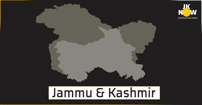
Jammu and Kashmir is more than just Kashmir
Jammu and Kashmir is more than just Kashmir
JK NOW TEAM
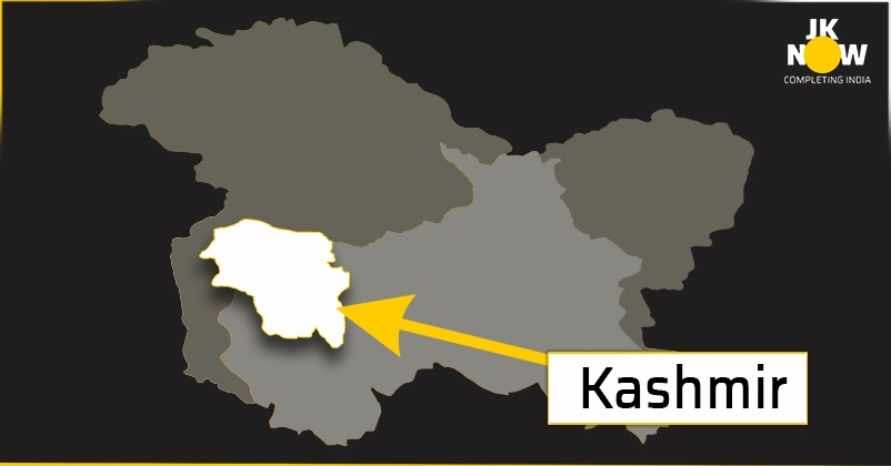
For many people, the State of Jammu and Kashmir is Kashmir, a 16% of geographical area of the entire state under administration of India after Pakistan has illegally occupied the large tract of land of Jammu and Kashmir. Unfortunately, the tradition went on since the time of British occupation of India though Kashmir was only just 7% of the entire state of Jammu and Kashmir then. But such a reference has made perception of many people that Jammu and Kashmir State prominently comprises of Kashmir Valley.
A brief review of the Geo -Administrative order of Maharaja Hari Singh’s Princely State of British Indian Empire would give some true understanding about Jammu and Kashmir State and affairs of this state, which is most discussed Indian state. As already stated, earlier in the nineteenth century, Maharaja Gulab Singh of Jammu & Kashmir extended the Geographical boundaries of India to the other side of Himalayas. Maharaja’s forces even routed the Tibetian army. Zoravar Singh, the great general of Raja Gulab Singh, had followed the route through Kishtwar in 1830s. Since that time Kashmir valley was not governed by Gulab Singh. Jammu and Ladakh regions were already part of Jammu Raj before the control of the Kashmir Valley was also transferred to Jammu Raj.
Maharaja Gulab Singh annexed Kashmir on 15-03-1846, which was given to him by the East India Company, through a treaty. Since then, the Jammu Raj was named as the State of Jammu and Kashmir. A fair and honest trial could be done by looking at the structure of Civil Administration given to J&K by Maharaja Hari Singh.
Civil Divisions/Administration
For the purposes of civil administration, the state was divided into three parts; 1. Province of Jammu [app 14010 sq miles/36,315 sq km). It had 5 Districts (17 Tehsils) and 2 jurisdictional Jagirss, 2. Province of Kashmir (8569 sq miles/22,000 sq km). It had 3 districts (10 tehsils), 3. district of Ladakh. The head of revenue administration in each province was a Governor. Ladakh district was under a Wazir Wazarat.
The Region wise area details mentioned in the administrative report of the State of Jammu & Kashmir 16 10 1940 to 15-10-1941, are – Jammu province was 36315 sq km (32,145 sq km + 4,170 sq km)/14,010 sq miles (12,401 sq miles plus app 1609 sq miles of Jagirs), the area of Kashmir Province/Jehlum valley was 22,133 sq km (8,539 sq miles), the area of district of Gilgit and frontier illaquas of Skardu, Ladakh and Kargil was 1,64,739 sq km (63554 sq miles). As per the Website of J&K Raj Bhawan (10-04-2013)( Refrence) the total area of the State is 2,22,236 sq. km including 78114 sq. km under the illegal occupation of Pakistan and 42,685 sq. km under that of China. (the data on Websites under Pakistan control—so called ‘Azad Kashmir’ i.e. Mirpur/Muzaffrabad etc. 13,297 sq km; Gilgit/Baltistan Northern Areas 72,496 sq km—and even in some other official documents could be with some variations but the differences need not matter for reviews like the one being made here). Surveyor General of India had issued provisional figures as 2,22,236 sq km. Subject to verification for taking a general note of the situation the J&K territories under illegal occupation and control of Pakistan and China (as per J&K Raj Bhawan website) could be said as about 54% of area (4. 5% is from Jammu province, 2.78% of Kashmir region and rest is from of Ladakh region). The present area that is often covered for elections from Jammu Region is about 162% of Kashmir Region (on over all based on the times of Maharaja Hari Singh Jammu Region could be said as 174% of the area of Kashmir Valley). Excluding the areas occupied by Pakistan in 1947 area left in Jammu Region was around 26,293 sq km (out of total of 32,145 sq km + 4,170 sq km Poonch and Chenani Jagirs = 36,315 sq km), as left in Kashmir Region was 15,948 sq km (out of total 22,133 sq km) and in Ladakh Region around 96,701 sq km (out of total 1, 64739 sq km) sq km).
Control of 5,180 sq km of areas out of the areas occupied by Pakistan in October 1947 was given by to China in 1963 (it has also been confirmed by GoI in reply to Rajya Sabha Question No: 367 from Chandra Mitra on 15-03-2012).
Kashmir Province: (8,539 sq miles/22,000 sq km):
In 1947, the Geographical Division of J&K comprising of the Jhelum Valley (consisting of the valleys that drained into the Jhelum and Krishan Ganga rivers) and the lateral valleys of the Sind as well as that of Liddar together form the famous Kashmir Valley. Kashmir Valley along with the hilly track of Muzaffarabad included in Kashmir Province. It is the Kashmir Region of today. Kashmir Valley along with the hilly track of Muzaffarabad included in Kashmir Province. The Princely State of Jammu and Kashmir was also referred as KASHMIR State, but such a reference has made many people to feel that Jammu and Kashmir State prominently comprises of Kashmir Valley only whereas the Kashmir Valley is a small part of Jammu and Kashmir State.
Province
District
Tehsil
Niabat
1.Kashmir
1.Anantnag
1.Anantnag. 2.Kulgam
3.Awantipura. 4.Srinagar
-
-
2.Baramulla
1. Baramulla
2.Sripratapsinghpura
3.Uttarmachhipura
-
-
1.Gurez. 2.Sopore
3.Muzaffarabad
1.Muzaffarabad.
2.Uri
3Karnah
Jammu Province: (app. 14010 sq miles/36,315 sq km). It extended over the Semi-mountainous and Sub-mountain tract consisting of the plains contiguous to the Punjab and broken Kandi country skirting the Himalayan ranges. The rivers Ravi, Chenab, and Jhelum and several perennial streams flowing through. The hills in Bhaderwah, Doda, and Kishtwar formed part of this Division. Jagirs of Poonch and Chenani too were with this Province. This Division comprised the whole area covered by the ranges of low hills to the south of Pir Panjal Mountains which divide the two provinces of Jammu and Kashmir.
Province
District
Tehsil
Niabat
2. Jammu
1. Jammu
1.Jammu .
2 Samba
3.Akhnoor
4.Ranbirsingh Pura
-
-
2.Mirpur
1. Mirpur .
2. Bhimber.
3. Kotli
1. Noushera
3. Udhampur
1.Udhampur. 2. Ramban
3Ramnagar. 4.Bhadarwah
5.Kishtwar
-
-
4.. Reasi
1. Reasi.
2.Rajouri
1.Gulabgarh
5. Kathua
1. Kathua.
2.Jasmergarh.
3.Basoli
-
3 Jagirs*
*Jurisdictional
1.Poonch Jagir
2.Chenani Jagir
*Jurisdictional 1 Poonch Jagir 2. Chenani Jagir
Ladakh (63,554 sq miles/1,64,748 sq km): The Tibetian and Semi Tibetian tract, that consisted on middle reaches of the Indus formed this Division (Ladakh District of Maharaja’s Administration comprising of district of Gilgit and the frontier illaquas of Skardu, Ladakh and Kargil). The river Indus having its source in Mansarovar lake in Tibet traversed the whole of this Division (district) running from south east up to the bend around the Nanga Parbat, where it assumes a south westerly course. Except in Gilgit, the ranges in this Division vary from 17,000 feet to 22,000 feet.
Crop area in Ladakh was very small. Mountains in the North stretch up to Pamirs. Mount Godwin Astin, 28,265 feet above MSL was the second highest known peak in world. Bhotia and Shina spoken in Ladakh and Gilgit remained confined to Ladakh.
Province
District
Tehsil
Niabat
*
1. Ladakh
*Ladakh had direct
Administration
Under a Wazir Wazarat
1. Ladakh
2. Kargil
3. Skardu
-
-
-
Astore was under a Revenue Assistant and ## Ladakh had nearly Direct Administration under a Wazir Wazarat. In 1935 when Soviet Russia nearly over ran Eastern Turkistan , the British executed an agreement with Maharaja Hari Singh and took Gilgit on lease under which the administration and defence of Gilgit became the subject of the British. An irregular corps , the Gilgit Scouts was raised for the purpose. In 1947 Gilgit was administratively/ technically transferred back to Maharaja. Frontier illaqas of Skardu , Ladakh and Kargil was 63554 square miles (1,64739 sq km). The population was very sparse.
In Jammu Province of erstwhile Princely State of Maharaja Hari Singh the Muslim formed a large portion of population but the Jammu Province still extended over larger part of the domain as compared to Kashmir Province without any communal overtones and considerations. Where as a just and rational segmentation of the civil administration looking at the ethnic/ cultural /geographical physicals for the welfare of the masses had been the prime consideration with Maharaja. On the whole the Muslim population was nearly 77 % of total population of the State as per 1941 census.
Since the common man has very less information and is innocent, some have succeeded in even terming the demand for separate State of Jammu - extending over the territories of Jammu Province of the State of Jammu and Kashmir as a Hindu dominated area demand, which is surely a wrong propaganda.